05/02/2007 to 05/20/2007
We did not make it to New England on our first try, so we decided this was the time for a second attempt. We also figured since we were "in the hood" we would just drop over the border into Canada to see a bit of New Brunswick.
Our route took us through Kentucky, Vermont, over into New Hampshire, through Maine, up into New Brunswick's interior, south along the coast and The Bay of Fundy, through a lot of little towns and villages, then along the coast of Maine and down to Maryland.
First, the weather was really awful all over New England and Canada. Rain, wind, cold and then more rain and cold. Torrential downpours were not uncommon. We went from Plan A to Plan B, C, D & E.
Second, did you know that the New Brunswick Province closes until Victoria's Day? Well we didn't. Not much is open including information centers, restaurants, attractions and hotels. Still we managed to have a great time and see some wonderful things.
While in Maryland we went to the Manassas National Battlefield Park. Just can't pass up an opportunity to visit one more park.
As usual we took a ton of pictures, put almost 8,000 miles on the truck, and enjoyed ourselves immensely. We must be nuts.
- Mammoth Cave - Kentucky
- New Hampshire
- Kancamagas Highway
- Maine
- New Brunswick - Covered Bridges
- New Brunswick - Fundy National Park
- New Brunswick - Village of Alma
- New Brunswick - Cape Enrage
- New Brunswick - Hopewell Rocks
- Fundy National Park - Dickson Falls
- Manassas National Park - Virginia
We just can't resist a cave, and we realized if we altered our route just a bit we could squeeze in at least one cave tour. Mammoth Cave is an amazing place. Naturally we plan to come back.
We chose The Historic Tour since it fit our timetable.
As usual the ranger gave the speech "don't go if you can't crawl, tolerate heights or small places".
And as usual one person who should have listened did not.
We spent about 20 minutes in Fat Man's Misery waiting for a woman to be helped through by the ranger. Then she almost had a heart attack climbing the tower to get out!
But that aside it was a lot of fun.


The historic entrance to Mammoth Cave

Pipistrel Bat. There aren't many bats in the cave, but he was a cutie

The first decent into the cave

During the War of 1812 they mined saltpeter for gunpowder

The miners hollowed out logs to use as pipes to pump water into the mine and calcium nitrate back out

Early in it's tour history black slaves would write tourists names on the ceilings for them. Amazing since slaves were illiterate

One of the narrow passages

Winding through Fat Man's Misery

Yup, I'm waiting while the ranger helps the person who shouldn't have come through the passage

Great Relief Hall opens up right after Fat Man's Misery. There are even toilets

A shot of the tower you have to climb to get out.

Leaving the cave
New Hampshire is a great place to tour.
Some of the attractions we wanted to do were not open yet because it was early in the season, but we did get a start on our covered bridges and waterfalls.

Swiftwater Covered Bridge


Yup, it's the Swiftwater River. I'd say it's aptly named

On the road up to Mt. Washington we passed these great cascades - Flume & Silver

Flume Cascade


Silver Cascade.

If you watch election news you're familiar with Dixville Notch

All the while I thought the candidates and reporters were roughing it in a little Mom & Pop Motel. Huh!
The Kancamagas Scenic Highway, or The Kanc, is 34 miles of scenic beauty running between Lincoln and Conway, New Hampshire.
We stayed in Lincoln at The White Mountaineer in a little 2 room cabin. If you ever go to Lincoln eat at The Common Man. The food is very good and the atmosphere is nice and inviting.

Kancamagas Highway


Sabbaday Fall

Lots of moss covered trees around the falls

It would be interesting to see how this looks in late summer


The Albany Covered Bridge

The sign says it was built in 1858 and renovated in 1970

This little cutie was in the woods on one of our hikes

We liked this because you can really see what he's eating

Rocky Gorge is another site on the Kancamagas Highway

You can not swim in this area and I think you can see why

Rocky Gorge is a pretty park area. If the weather is nice you can picnic
Our drive through Maine was just that, a drive.
We saw a lot of pretty areas and Moose. Yes, . So you get to see our moose shots. Three different moose that moose we saw along the highway.
Other than some really beautiful scenery and the moose, we did not get too much done in Maine, except the Katahdin Iron Works, or rather, what's left of them.
But enjoy the little bit we did get. Did I mention we saw MOOSE?

Just over the border from New Hampshire we saw this really neat dam

The Aziscohos Dam

Our first moose was a young one just hanging along the side of the road

He's pulling out tufts of winter coat

His closeup

Moose 2 was also along the roadside, just hanging out

You can see the beginnings of antlers on this one

Moose 3 is a good example of why you see the Brake For Moose signs

Classic moose shot

So what are you going to do if you see a moose in the road? DUH!

Raye's Mustard Store in Eastport, Maine has been making mustard in this store since 1900

Mt. Katahdin.

OK, it's not our shot. When we were there it was pouring rain and freezing. But we would have taken the boot shot if the camera was waterproof


The remaining furnace

I'm in there for scale


The remaining kiln
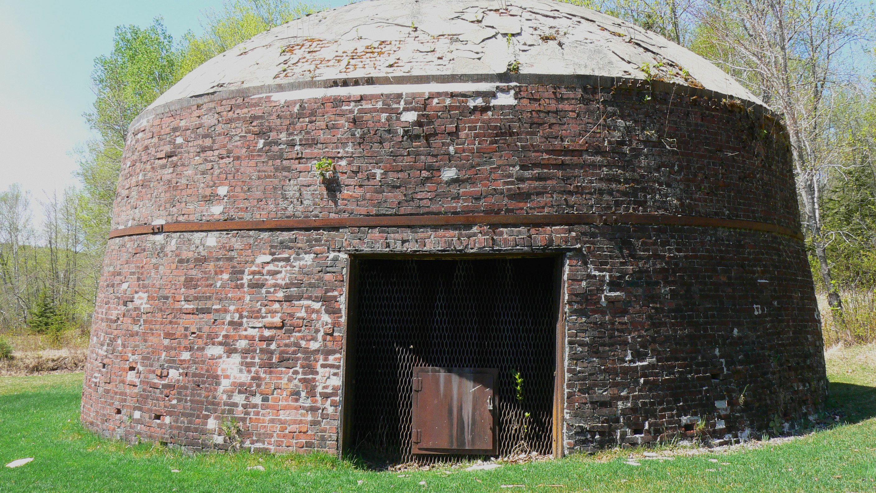

The kiln and the furnace
This province has quite a few covered bridges and we only managed to see those we passed along the way.
As you drive along those little two lane roads you see "covered bridge" signs and naturally you make an immediate turn to follow the sign so you can take just one more neat little picture.
A bit of trivia - a bridge needed to be wide enough and high enough for a cart of hay to pass.

Sawmill Creek Bridge is in the area of Hopewell Rocks

Sawmill Creek Bridge

The sign on the right says "Walk your horse and save a fine"

Point Wolfe Covered Bridge

This is a recent bridge - 1992. Nice they still value these up here.

The MacFarlane Bridge over Wards Creek


The Hardscrabble Bridge on the Irish River in St. Martins

As you can see that famouse Fundy tide is out


I liked the little pedestrian walkway on Hardscrabble

A classic bridge and house shot

The bridge on Tynemouth Creek


Tynemouth Creek was at low tide here. Its so odd to see boats sitting in the mud
If the weather had been better we would have enjoyed some of the longer hikes, but since we are wimps when it comes to rain and temperatures in the 40s we opted for some of the easier venues. The area is so beautiful you just can't make a poor choice.

We stayed at the Highlands Inn & Chalet inside Fundy Park.

Our little cabin. It was quite nice, clean, and so quiet

This is Herring Cove. Yes there was a herring industry here once

The very high tides have created small caves in the rocks along the cliff

Point Wolfe Beach Sign

This is the site of the old sawmill at Wolfe Point

Looking out towards the bay from Wolfe Point

This is the beaver pond at Caribou Prairie

These were the most colorful birds we have seen, but they moved so fast it was hard to photograph them

I assume this is the female of thes species
As you drive along the coast you will come to the Village of Alma.
Not only is it the gateway to Fundy National Park, but it is very quaint and boasts the highest tides.
When the tide goes out, it really goes out. Fishing boats must wait at sea for it to turn before they can come back into the harbor.


A little map of the town is included

Boats at high tide

Tide going out

Tide is definitely out. These boats are sitting in the mud

High tide

Tide going out - you step down a bit to the boat

The only other time I've seen boats sitting in mud was after a hurricane threw them on shore

High Tide

Tide going out

This is just so odd

The beach at high tide

The beach at low tide
Moving down along the coast, and off the highway a bit, is Cape Enrage. It has a pretty amazing history, the latest of which is it's rescue and restoration by local high school students. Click on the link below to read the story.
There are 2 beaches - well not in the sense of sand and surf - but more of rocks and fossils.

There are adventure programs offered during the summer. We missed out

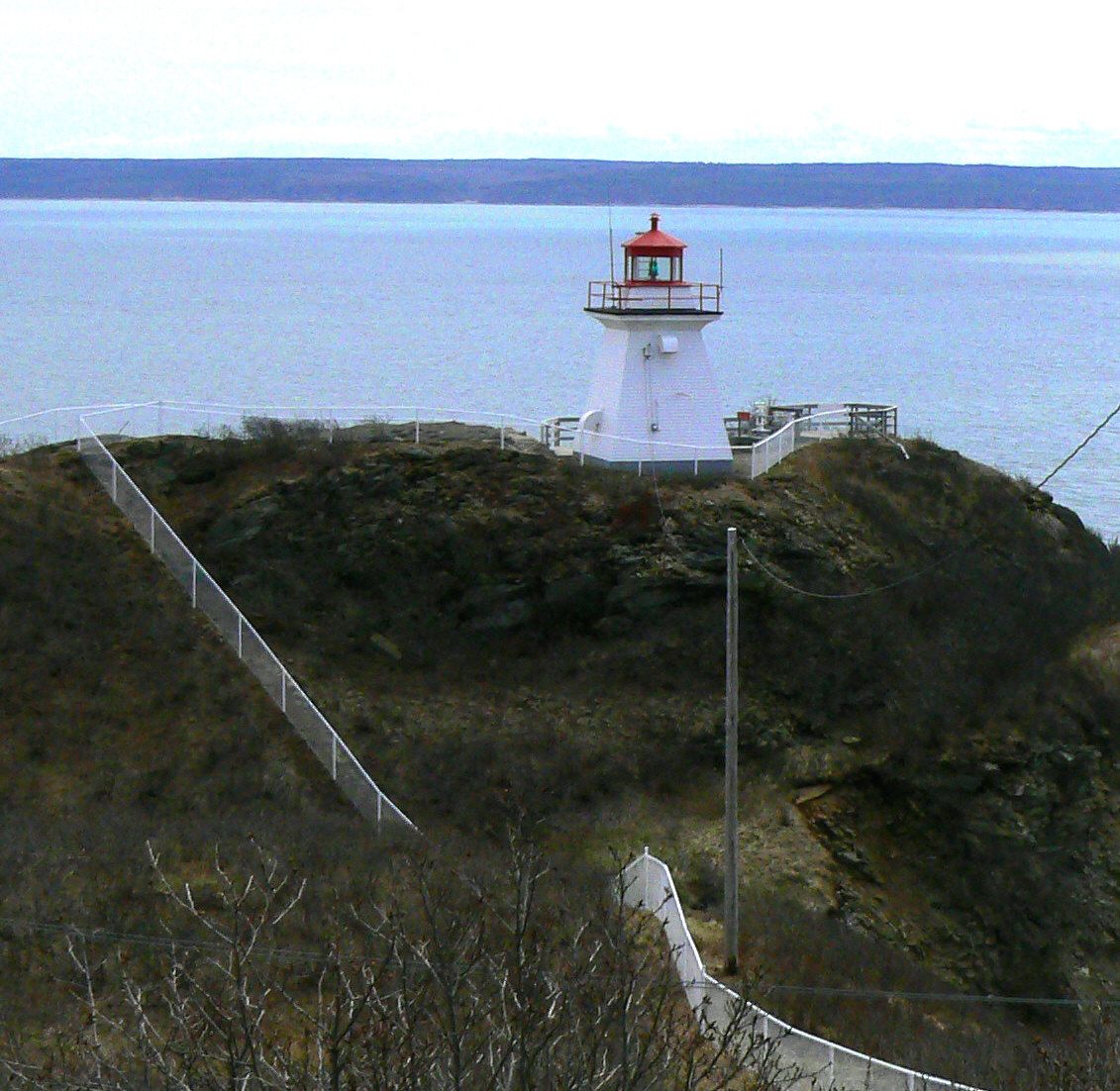
The lighthouse is still working and they warn you the horn may sound while you are out there

This is the old keeper's house. It has been restored by the students

Heading down to the "beach"

As you can see it is all rocks

The rocks have fallen from the cliffs you see here

It's really hard to capture the scale of these cliffs against the beach

These are the stairs you take to get down to the beach

Samauri Beach again

This is the second beach called Samauri Beach.
Heading south along the coast of New Brunswick you enter The Bay of Fundy area.
One of the first amazing sites you see are The Hopewell Rocks, also known as The Flowerpot Rocks. They are part of a park which was still closed for the season, so we could not get down to the base. When the tide is out you can walk through these huge formations and stroll along the beach.


We met some nice Canadians who took our picture


It's not hard to figure out where the "flower pot" came from


If the tide is out you can wander through those arches
Dickson Falls is a beautiful stroll along paths and wooden walkways. It takes you down to the stream and along the series of falls. Lots of little creatures along the way, as well as some lush green moss and ferns.

Dickson Falls Sign

The first falls you see - if you head right down the trail

From the bridge you see a set of smaller falls up the stream


As you go along up the stream those little falls become more apparent

Yes, I'm cold

Cute little red squirrel nibbling on something

The classic moss covered log shot

George is smiling - cold but smiling

These are the higher of the falls

From that bridge you get a good look at the top

The chipmonks are quite bold and people don't seem to upset them
Since we were spending time in Maryland before heading home we took a day and went to Manassas National Park in Virginia.
As I'm sure you all remember from your history classes Manassas, also called Bull Run, was the first major battle of the Civil War and it's the one were General Jackson got the nickname Stonewall.
The South named battles after towns or railroad junctions. The North named them after the closest river or stream.
So, it was the Battle of Bull Run or The Battle of Manassas, depending on which side you were on.


Depending on how you feel you can walk the various routes around the battlefield. This one is going passed the stone house

Every effort is made to place cannon in the area they occupied during the battle. You can see how close they are to the Henry House


The Henry House

The stone house. It was used as headquarters during the battle

Yup, that's Stonewall Jackson's statue

Bull Run stream

The stone bridge over Bull Run